Recording and uploading your Flysight tracks on Skyderby is the easiest thing in the world: you can have your track online already 30 seconds after landing. All you need is a phone and a short USB cable in your pocket.
If you have never used Flysight before, this is a simple routine:
1. On arrival at the exit point, turn Flysight ON for 10-15min so it can download satellite data, then turn it OFF. This only needs to be done once a day (i.e. before the 1st jump of the day).
2. Turn Flysight ON a couple of minutes before the jump (i.e as you zip up).
3. Turn Flysignt OFF immediately after landing (NOT under canopy).
4. Plug USB cable into Flysight & phone, open skyderby.ru, click on "Upload Track" (Big Green button) and choose your file on the USB drive. Bingo!
Fine print:
1. Skyderby will automatically pick the perfect track start point.
2. If you didn't flare hard, it will typically pick a perfect finish point at deployment.
3. For the tracks where you did go up, it will typically cut the track at the flare start. You certainly want to fix this bit and capture the entire flare: click on "Edit" button and move the red slider (deployment side) one or two steps to the right. Click on "Save", and the track will be cut at the actual deployment (i.e. where your horizontal speed is dropping and vertical is increasing again - this is rather intuitive). Experiment with the slider, it is typically just one incremental step, but might be a couple for a monster flare. Do not move the slider all the way to the right - including canopy time on the chart makes it messy and harder to read.
4. Skyderby will automatically pick the closest exit point from the list it has. If you jumped something unlisted - just type the name in. If you want to add a new exit to the list, send the GPS coordinates (and laser profile if available) to Aleksandr Kunin or myself.
5. Pick a correct suit from the drop-down menu if you want to see your data under "Results" tab (i.e. Flare UP, Kings, Feather etc), and for the track to show in various online rankings. If your suit is unlisted, pick "Custom wingsuit" or "Custom tracksuit" from the list, and spell out any details in Comment box as you wish.
6. Don't forget to choose "Skydive" or "BASE" toggle, and privacy options (Public, Unlisted or Private) before upload. Unlisted tracks can be shared with friends via a direct link, Private will be un-shareable.
Tips for analyzing your tracks:
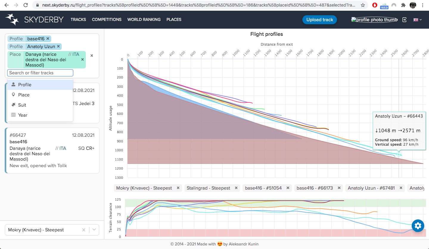
1. Use the new beta version of the flight & terrain profiles at https://next.skyderby.ru/flight_profiles to analyze any tracks you wish. Just filter by pilots, places, suits etc, and choose any terrain profiles to overlay. It will show terrain clearance for the primary exit point profile, and also let you choose a secondary terrain profile overlaid on top of it if you you want to visually compare two exits.
2. Upload your video on Youtube and synch it on Skyderby to have all your flight data overlayed on the video. IT works fine on the current version (https://skyderby.ru/tracks/61102/video) and is even better to watch in the new one (https://next.skyderby.ru/tracks/61102/video).
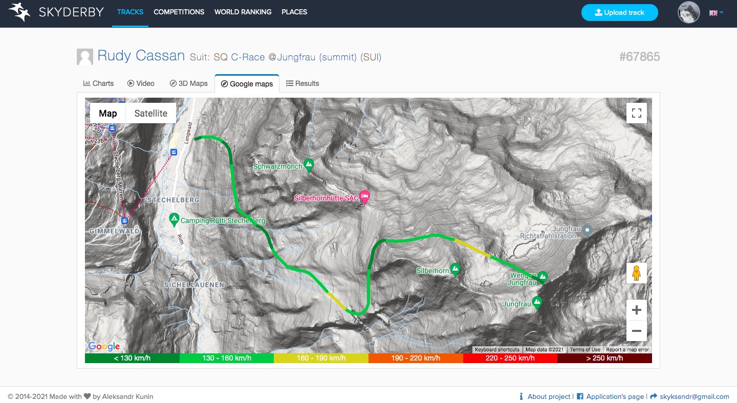
3. "Google Maps" view of the track is a very useful tab.
P.S. For those still jumping Notch Peak and such: Mr Wolf says "Move outta the sticks, fellas", get your 5G vaccine shot already, or just wait till you're back in civilization.
P.P.S. Oh yeah, do switch to Android phone! You need it to record your laser profiles in BASELine app, anyway ;)